Day 20.
Excerpts from journals of Alexander MacKenzie's Voyage to the Pacific Ocean via the Peace River.
“The day was very cloudy. The mountains on both sides of the river seemed to have sunk, in their elevation, during the voyage of yesterday. To-day they resumed their former altitude, and run so close on either side of the channel, that all view was excluded of everything but themselves.”
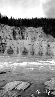
It’s easy to see what he means, by looking at the area on Google Earth, or on a contour map. He is in the heart of The Rocky Mountain range. Large peaks are very near the river channel, on both sides. (Picture 1, taken 1906)
“In the afternoon we approached some cascades...Here we observed an encampment of the natives, though some time had elapsed since it had been inhabited.”
He doesn’t tell us how many miles he has gone, due to the fact that he lost his book of course notes for these days. However we know where he was camped on the 27th and that he is heading west. He doesn’t know it yet but he will soon be at the forks, at the headwaters in the Rocky Mountain trench where the Peace River is formed by rivers joining it from the north, and south.
“We took our station on the shore about six in the evening, about three miles above the last rapid.”


No comments:
Post a Comment