Saturday, June 13, 2020

June 13, 1793. The canoe is wreck'd

June 13, 1793. 227 Years Ago To-day. Excerpts from the Journal of Alexander MacKenzie’s Voyage of Discovery to the Pacific Ocean

     “At an early hour of the morning the men began to cut a road, in order to carry the canoe and lading beyond the rapid...by seven they were ready...In order to lighten her, it was my intention to walk...but those in the boat...requested me to embark, declaring...if they perished, I should perish with them.” 
I guess the crew would like the Captain to go down with his ship, if it’s going to sink. And it’s not very long before something bad does happen.

     “The violence of the current was so great...when we drove against a rock which shattered the stern...drove us to the opposite side of the river...when the bow met the same fate...At this moment the foreman seized on some branches of a small tree in the hope of bringing up the canoe, but such was the elasticity that, in a manner not easily described, he was jerked on shore in an instant, and with a degree of violence that threatened his destruction...in a few moments, we came across a cascade which broke several large holes in the bottom of the canoe...we all jumped out...and they all held fast to the wreck...at length, we most fortunately arrived in shallow water...though our efforts were short, they were pushed to the utmost, as life or death depended on them.”

Things happen fast on the river, and fortunes can change in an instant.  

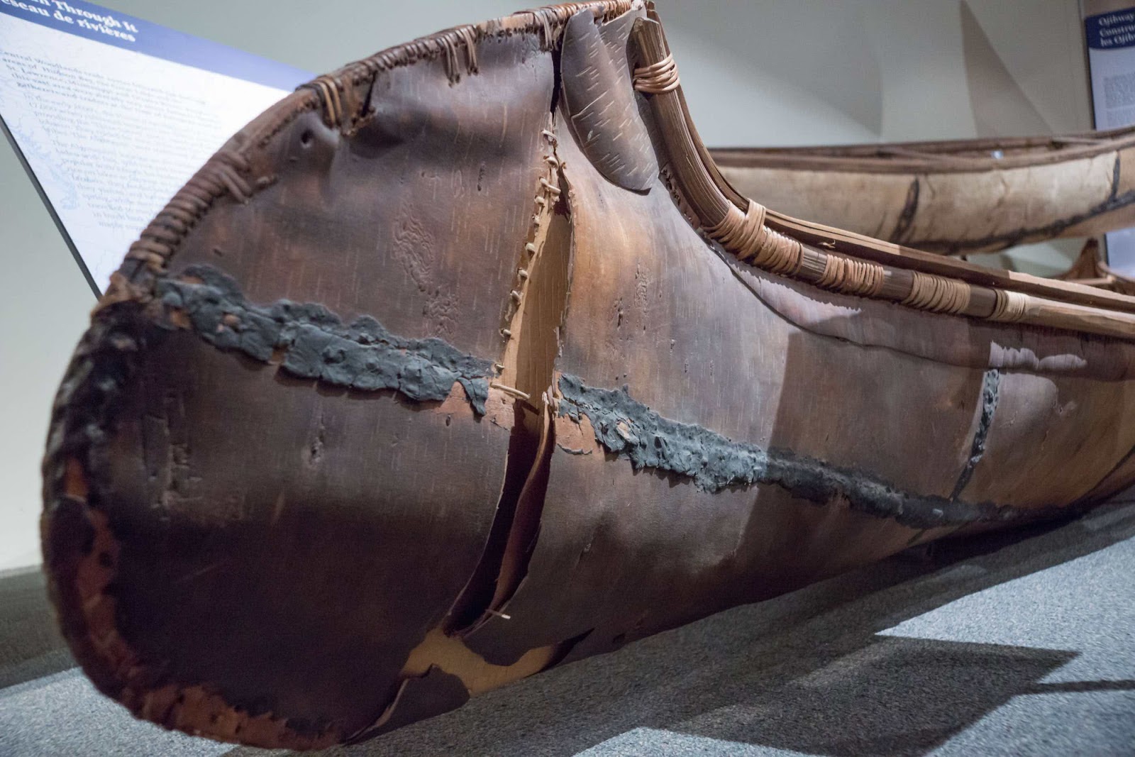
Picture 2. A museum specimen of an 1850 Ojibway canoe, shows how damage can occur.


“This alarming scene, with all its terrors and dangers, occupied only a few minutes...we called to the people on shore...The foreman...had escaped unhurt from the extraordinary jerk with which he was thrown out of the boat...I remained till everything was got on shore, in a state of great pain from the extreme cold of the water...it was with difficulty I could stand, from the benumbed state of my limbs.”

And the day is just beginning. But first comes the realization of what has been lost during the wrecking of their vessel. 
     “The loss was considerable and important, for it consisted of our whole stock of balls, and some of our furniture...All the different articles were now spread out to dry. The powder...had received no damage, and all my instruments had escaped.”
They have lost most of their stock of musket balls. They do however still have shot, which can be used for fowl, or if necessary melted down and recast into balls.

Some of the men were “by no means sorry” about the wreck, as they felt that this must put an end to the voyage and they could now return. MacKenzie listened to their pleas but didn’t reply to them until they finished a hearty meal and “rum enough to raise their spirits.”
     “I then addressed them...recommending them all to be thankful for...their escape...I brought to their recollection, that I did not deceive them, and that they were made acquainted with the difficulties and dangers they must expect to encounter, before they engaged to accompany me.” 
      In other words, they knew when they signed up that this journey was not going to be a picnic, or a walk in the park. He has written a very detailed account of this day and all its trials, and it makes for good reading. I have attempted to get the gist of his story today by quoting the most pertinent parts of it.   
“I now joined my people in order to repair...our wreck of a canoe, and I began to set them the example.”

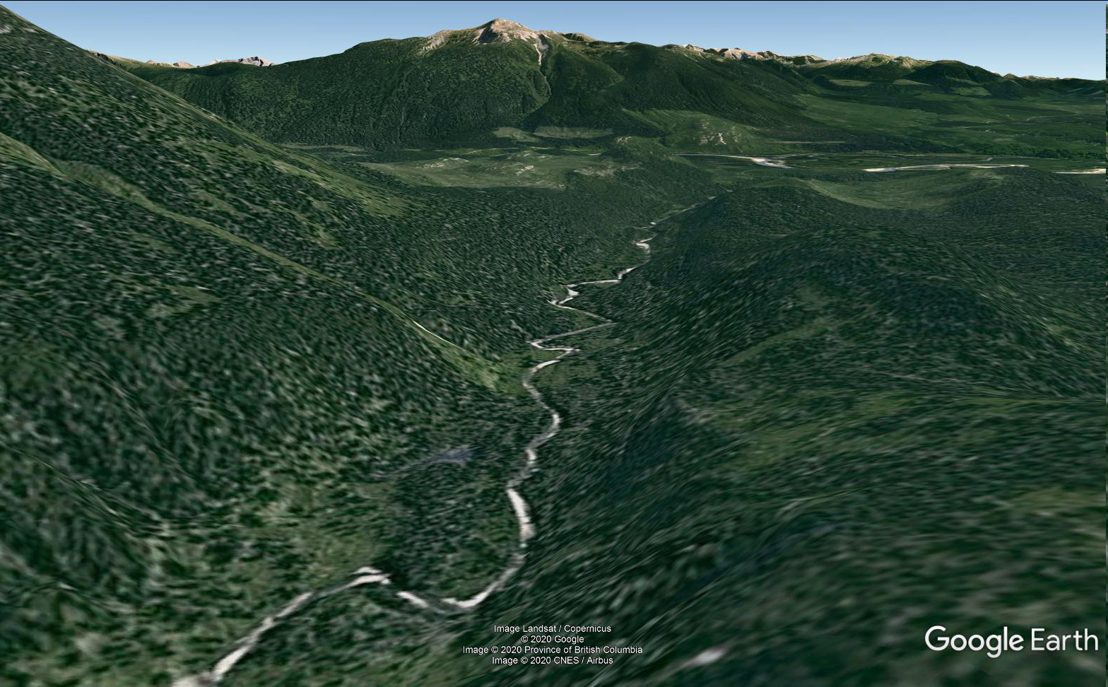
     They just yesterday crossed the divide, and only moved a few miles into the Pacific drainage, yet he has already noticed changes to the forest cover. This is the intense and very dangerous James River, which they have to get down, even though it is almost impassable. It might be noted here that this route he has taken, to find the “òther river”`is not the best one that he could have taken. Simon Fraser and others following later will use a different, and much easier route to it.
     “I observed several trees and plants on the banks of this river, which I had not seen on the North of latitude 52, such as the cedar, maple, hemlock, etc.”


Friday, June 12, 2020

June 12, 1793. The Divide.

June 12 , 1793 (Day 35)
Excerpts from the Journal of Alexander MacKenzie on his epic Voyage of Discovery to the Pacific Ocean.
     “The weather was the same as yesterday, and we proceeded between three and four in the morning. We took up the net which we had set the preceding evening, when it contained a trout, one white fish, one carp, and three jub.” 


Picture 1. Showing a “Jub” fish.

     “The lake is about two miles in length, East by South, and from three to five hundred yards wide. This I consider as the highest and Southernmost source of the Unjigah, or Peace River…”
Arctic Lake. 
     This area containing the old indigenous route is now protected and is known as the Arctic Pacific Lakes Provincial Park. The main feature of the 13,887 hectare park is three small lakes that straddle the Continental Divide in a narrow, steep-sided glacial overflow channel. “The lake” he refers to here is Arctic Lake, and is located in the headwaters of the Parsnip River drainage that eventually drains into the Arctic Ocean. These lakes and streams support diverse fish populations, and today, as then, provide excellent opportunities for sport fishing. Diverse fish populations including lake trout, bull trout, rainbow trout, kokanee, dolly varden, mountain whitefish, redside shiner, lake char, and chinook salmon, and arctic grayling in Arctic Lake. In just a few years time the river MacKenzie has just traced to its source will become known as the Parsnip River, and as a tributary of the Peace. 

Picture 2. Arctic Pacific Lakes Provincial Park. (BC Parks photo)
     
     “We landed and unloaded, where we found a beaten path leading over a low ridge of land eight hundred and seventeen paces in length, to another small lake...this being the highest point of land dividing these waters, and we are now going with the stream.”
     In those 817 paces, Alexander MacKenzie has just crossed the Continental Divide. The waters of the now aptly named Portage Lake, and all the water ahead of him will drain into the Pacific. Most importantly, they are now “going with the stream”, and no longer have to work at paddling and poling against the current.

“At five we entered  a small round lake of about one third of a mile in diameter.” 
Little Lake. 
     “At half past six we were stopped by two large trees that lay across the river...Here we unloaded and formed our encampment.” The campsite of this day is one hour and half (by birchbark canoe) SE of Little Lake. “At this place our guide manifested evident symptoms of discontent...expressed an anxiety to return. He shewed us a mountain, at no great distance, which he represented as being on the other side of a river, into which this empties itself.” 

Picture 3.
This Google earth Image is taken from just above the site of June 12 camp, looking SE. The “Mountain on the other side” is at centre top of this image.


Thursday, June 11, 2020

June 11, 1793. One Beautiful Hummingbird.

June 11, 1793. 
227 Years Ago To-day.
      “At four we continued our voyage...A river appeared on the left, at the foot of a mountain which, from its conical form, my young Indian called the Beaver Lodge Mountain. Having proceeded SSE half a mile, another river appeared from the right...”
     He has engaged the services of a native guide to help him find the other river; whom he refers to here as his “young Indian”.  The conical shaped mountain is where the Missinka River meets the Parsnip River, appearing on his left as he is going SSE. 

Picture 1. 
Top of Google image is North. The “conical mountain” can be seen in the top left. 


“We now came in line with the beginning of the mountains we saw yesterday: others of the same kind ran parallel with them…”

        The Missinka River joins the Parsnip at the foot of the “Beaver Lodge Mountain”. A little ways further, and the Wichcika River flows in from his right. They travelled down this valley of parallel mountains, then followed the river as it turns East (to their left). The river course is easily seen in Picture 1,  as it heads up into the mountains, on the RH side of this Google Earth image.

     “Here we quitted the main branch, (of The Parsnip) which according to the information of our guide, terminates at a short distance...supplied by the snow which covers the mountains...The water, however, was so high, that the country was entirely overflowed, and we passed the canoe among the branches of trees…”

As can be seen in Picture 1 they have travelled through a large low lying valley that can easily be imagined as a large swamp or shallow lake in times of high water; a perfect stopping place for  swans, geese, ducks and any migrating birds.

      “We advanced about a mile in the lake, and took up our station for the night at an old Indian encampment. Here we expected to meet with natives; but were disappointed...(during this day) we saw beaver...there were also swans in great numbers, with geese and ducks...we  observed also the tracks of moose-deer...parsnips grew here in abundance, which have already been mentioned as a grateful vegetable. Of birds, we saw blue jays, yellow birds, and one beautiful hummingbird; of the first and last, I had not seen any since I had been in the North-West.”

Wednesday, June 10, 2020

June 10, 1793. Day 33. Fowling-Pieces.

Excerpts from the journal of Alexander MacKenzie’s epic Voyage Of Discovery to find an overland route to The Pacific Ocean. 

    “At ten we were ready to embark. I then took leave of the Indians, but encouraged them to expect us (to return) in two moons…We now pushed off the canoe from the bank, and proceeded East half a mile, when a river flowed in from the left, about half as large as that which we were navigating.” 
The Table River.
      “We continued the same course three quarters of a mile, when we missed two of our fowling pieces, which had been forgotten, and I sent their owners back for them…”
      In 1990 my brother found an old gun near the creek and beaver dam on his farm in Bonanza Alberta, just a few miles north of the Peace River. I always wondered how a trapper or fur trader could lose such an important item as his “fowling-piece”, but this journal entry shows that it’s possible to lose even something as important as your gun. The one my brother found is shown in Picture 1 & 2. It was made around 1800,  has a small circle about 0.4" inches in diameter with a sitting fox facing right, and the word "LONDON" to the right of it. 3 “wedding ring” bands also appear on the barrel, and help to identify it. These “Indian Trade Guns” were muskets made between 1790 and 1820 and were distributed in our area by the North-West Company. It was likely obtained from a trading post at Dunvegan or Fort St. John sometime in the early 19th century. The barrel has been shortened at some time in its history, likely because the barrel had been damaged. Some documents claim these barrels were made too light and if plugged at all they would split. A modified short musket barrel like this would be a handy tool for a trapper or explorer.


 “Here a river flowed in from the left, (The Hominka River) which was about one-fourth part as large...We then continued...to the foot of a mountain on the South...we landed at seven o’clock and encamped. During the greatest part of the distance we came to-day, the river runs close to the mountains on the left.” 

This can be seen easily with Google Earth. Top is North. Hominka River is shown flowing in to The Parsnip River from the East, at bottom of this image, and the “foot of the mountain on the South” is easily seen where the Parsnip changes its direction to SW. The Table River runs in from the East at the top of the image.

Tuesday, June 9, 2020

June 9, 1793. An Idea Too Painful.

Excerpts from: Alexander MacKenzie's epic Voyage Of Discovery overland to The Pacific Ocean.
June 9, 1793. Day 32. 

     “The rain of this morning terminated in a heavy mist at half past five, when we embarked…(13 ½ miles) here we perceived a smell of fire; and in a short time heard people in the woods, as if in a state of great confusion, which was occasioned, as we afterwards understood, by their discovery of us.” 
      Most of the journal entry on this day describes first contact; it is beyond me or the scope of this blog to take excerpts from it, regarding that experience. I suggest that those interested in learning more about this important part of the story read his account of it for themselves. (Vol ll, Chapter lV) 

     In this blog I am more interested in re-tracing his route; trying to determine where he camped, and where the adventures he describes actually took place. 
     “It was my purpose to continue my progress up the present river, as far as it was navigable, and if we did not meet with natives to instruct us in our further progress, I had determined to return to the fork, and take the other branch, with a hope of better fortune.” 
     It’s easy to see now, what would have happened to the voyage if he would have turned back and went north. He depends on the local natives to share with him their knowledge and information regarding any route or river to the Ocean.  
     “It was about three in the afternoon when we landed…”
     I believe this encounter, and encampment was located approximately where the Table River joins the Parsnip River. Google Earth Lat & Long 54.42.09 N and 122.17.30 W. It’s really interesting to see from above, the snake-like meanderings and oxbow lakes of the river in this part of it (Picture 1).


Picture 1. June 9, the meandering Parsnip River     
      “In this state of perplexity and disappointment, various projects presented themselves to my mind...At one time I thought of leaving the canoe, and everything it contained, to go over land…(but) it would be impossible for us to carry provisions for our support...at another time…(my desire to succeed) incited a wish to remain with the natives...would have required a portion of time which was not in my power to bestow...and to return unsuccessful, after all our labour, sufferings, and dangers, was an idea too painful to indulge.”

Monday, June 8, 2020

June 8, 1793. Parsnips.

June 8, 1793. Excerpts from the Journals of Alexander MacKenzie on this epic Voyage Of Discovery to the Pacific Ocean.
      “It rained and thundered through the night, and at four in the morning we again encountered the current. Our course was…(18 miles, mostly SE)... when the mountains were in full view in this direction, and Eastward ”

“For the last two days we had been anxiously looking out for the carrying-place, but could not discover it, and our only hope was in such information as we should be able to procure from the natives. All that remained for us to do, was to push forwards till the river should be no longer navigable…it was eight at night before we could discover a place to encamp.”


“Having found plenty of wild parsnips, we gathered the tops, and boiled them with pemmican for our supper.”  They have found the reason for the name of this river; in the journal he calls this part the south branch of the Peace River, a few years after completion of this famous journey it will be known from then on as the Parsnip River. Technically of course he is correct, as the parsnips are wild; however the type they are eating is the cow parsnip, not the one known today as the invasive species wild parsnip. (Pictures 1 & 2).


Sunday, June 7, 2020

June 7, 1793. Jupiter's Satellites.

June 7, 1793. (Lat and Long) 
Excerpts from the journals of Alexander MacKenzie on his Voyage of Discovery, 227 years ago to-day.
 
      “The morning was clear and calm; and since we had been at this station the water had risen two inches; so that the current became still stronger…”

       “I last night observed an emersion of Jupiter’s first satellite, but inadvertently went to bed, without committing the exact time to writing: if my memory is correct, it was 8.18.10 by the timepiece.”


      As mentioned before, he is using Jupiter’s moons as a celestial clock to help determine their longitude. 

      “The canoe, which had been little better than a wreck, being now repaired, we proceeded…” They made about three miles before noon when they landed again to determine the latitude. He finds the latitude to be 55.2.51 North.  “I find that my time-piece was slow 1.32.23 apparent time; and made the longitude obtained 122.35.50 West of Greenwich.” 
As usual, his latitude figures are probably very close to his actual location, however maybe his memory of the exact time last night was not correct. His reckoning of longitude is off; this time he is actually about 20 west miles of that point. 

“From this place we proceeded....(8 ¼ miles), and encamped at seven o’clock. Mr. MacKay and the hunters walked the greatest part of the day, and in the course of their excursion killed a porcupine...During the day several Indian encampments were seen...The current had also lost some of its impetuosity during the greater part of the day.”
      Something different in the Kettle tonight.